
As the clocks go back and the sun sets on one of the greatest cosmological minds in history, Stephen Hawking, it seems especially timely to explore one of South London’s greatest landmarks: the Prime Meridian at Greenwich, one of the most significant interventions by humanity to put the world as we know it into order.
Longitude: a Lesson in Geography or History
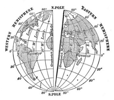
While the equator might be considered imaginary in the sense that it is not a literal line drawn in the sand, or cleaved in the sea, its physical effects are indisputably real. The sun, for example, sets and rises in a matter of minutes over the boundary line between the Northern and Southern hemispheres, the earth’s diameter is slightly wider here on account of the force of its rotation: creating a phenomenon known as the ‘equatorial bulge’ - making the earth an oblate spheroid rather than a sphere as it is commonly known. So, while the idea of it being a line might be imagined, there are physical and celestial phenomena that let us know where the latitudinal boundary line falls. Longitude is an altogether more slippery character. Bisecting the planet from the North Pole to the South (or South to North, but let’s not make this any more complicated than it needs to be!) Longitude 0º could technically be anywhere, with no signifying geographical phenomena to dictate them, meridian lines really could be described as wholly imagined. And yet, their effects are very real: the establishment of the Prime Meridian at Greenwich has given the world the means to measure and to share time - this totally invented point of significance has an objectively visible impact on the real order of the world as we know it.
To begin at the beginning: the system of Latitude and Longitude is first recorded as being proposed by the Greek mathematician, poet and astronomer Erastosthenes in the 3rd Century BC. A remarkable figure, he is credited as having invented Geography as it is known today, developed scientific chronology (he accurately dated political events back to the sacking of Troy in 1183 BC), devised the concept of the leap year, calculated the circumference of the Earth exceptionally accurately and, importantly, to have drawn up the first map of the world to use parallels and meridians.

Erastosthenes
Jumping ahead a hundred years or so, in the 2nd Century BC Erastosthenes’ work was taken up by another Greek thinker, Hipparchus, who proposed the system of determining longitude by comparing the local time at any one place to an absolute time - this was the first recognition of the link between the accurate determination of longitude an accurate determination of time. Following this, Ptolemy was the first to use a consistent or prime meridian in a world map in his Geographia, located in the ‘Fortunate Islands’ - now thought to be either the Canary Islands or the Cape Verde Islands. The moment of the lunar eclipse provided the most accurate means of understanding time differences for these early pioneers of time and space, local reports of precisely what time the sun vanished behind the moon helped them understand where places were in relation to the meridian.

Ptolemy's Geographia
Contrary to what these early developments may suggest, longitude remained a problem for nearly two millennia after the work of Erastosthenes and Hipparchus. On land, a fairly accurate system had developed using the Galilean moons of Jupiter, which were harder to discern at sea. Sailors were forced to use what was known as ‘dead reckoning’, calculating their current position based on their estimated distance from a previously known point and the speed they were travelling at. Naturally this resulted in a great deal of inaccuracy and was hugely costly, voyages were treacherous and shipwrecks common. The most often cited of these losses is the Scilly naval disaster of 1707, which has been directly attributed to sailors being unable to establish their longitude. This, along with errors in charts and poor weather that led to their colliding with the Isles of Scilly, and the loss of 1550 lives. Other costs that surely came into consideration by the Board of Longitude in their establishment of the Longitude Rewards in 1714 (handsome sums offered by the Government for a simple solution to the difficulty of establishing a ship’s longitude at sea) were those associated with the transatlantic slave trade, wrecks were common among the vessels as were massive losses of life which to this day remain largely unaccounted for. These rewards weren’t the first of their kind to be offered - Philip II of Spain offered 6000 ducats for the discovery in 1598, and the Netherlands promised 10,000 florins shortly after.

Harrison's Marine Chronometer
Answers came eventually in the link between time and space - literally. Spurred on by the promised reward, the self-taught carpenter and clockmaker John Harrison submitted his modification on the marine chronometer in 1730. The concept of the navigational timepiece that used celestial markers (moons, stars etc.) to establish time and therefore longitudinal position had been in development for nearly 30 years by this point - the first attempt having been made by the Dutch inventor of the pendulum clock, Christiaan Huygens, in 1673. Harrison’s persistence with the problem eventually paid off, and he was awarded a series of grants to continue his fine-tuning of the discovery, which is now recognised to have advanced British seafaring, exploration and the Colonial project considerably. Its legacy remains even in the age of GPS - celestial navigation through chronometer use is still a mandatory part of international mariner certifications.
Prime Time in Greenwich
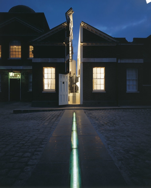
It is easy to see here how measurement, a science we now take for granted as an objective way of ordering the world (in things like time or maps or even our relationship with the stars) has massive significance for global politics and power. Imposing measurement becomes another way of extending influence and dominion over the world, particularly in Colonial contexts. Britain had been using the Royal Observatory in Greenwich as its Prime Meridian since 1721. The Observatory was commissioned by Charles II in 1675 and the recognition of astronomy’s significance for cartography and navigation was hugely influential in its inception. Built on the ruins of Greenwich castle, selected for its solid foundations and high vantage point, it was Britain’s first state funded scientific institution.
“The project was notable for the speed in which it happened, and for the small budget with which it was achieved. At 3.14pm on 10 August 1675, the first Astronomer Royal John Flamsteed laid the foundation stone of the new Royal Observatory and he moved in less than a year later on 10 July 1676 with his two servants to begin his observations in earnest. A total of £520.45 was spent on construction, with costs being kept down by using recycled materials.” - Royal Museums, Greenwich website.

The view from One Tree Hill of Greenwich Observatory
Over the years the structure grew incrementally to accomodate bigger and more advanced instruments, and more staff and occupants along with it. In 1818 the institution was given over to the Admiralty and expanded significantly.
The Dawn of the Universal Day

The Time Ball at Greenwich
The first Astronomer Royal, John Flamsteed - after which Flamsteed house is named - devised the concept of ‘mean time’ as the average length of the solar day. While precision was becoming increasingly important at sea, particularly following the introduction of the Nautical Almanac - lunar tables that used Greenwich Mean Time as their standard - which were the most effective development in maritime navigation yet, back on dry land, things were a little more choppy. Incredibly, individual towns continued to set their own time until the mid 1800s, working in harmony with the sun and the seasons. However with the vast expansion of the railways across the UK and indeed the rest of the world, and the industry this brought along with it, the need for a standard time became more pronounced. The first public time signal in the country came from the Observatory in 1833 with the first dropping of the Time Ball, at 12:55 pm GMT the ball was hoisted halfway up its pole before being dropped from the top at 13:00 precisely. It is a signal that continues to this day. GMT was officially adopted as ‘railway time’ in 1847 and the Master Clock was installed at Greenwich in 1852, from then on its tick was the pulse of British time - it was sent by telegraph to cities around the UK and from 1866 sent by the new transatlantic submarine cable to Harvard University in the US, who began to run their own industry by British time.
1884 was the year GMT’s position was cemented in history, when the International Meridian Conference was held in Washington D.C. to agree on the earth’s prime meridian “to be employed as a common zero of longitude and a standard of time reckoning throughout the world.” It had become clear that the political and economic unification of the world was dependent on the standardised organisation of time and the ability by nations to recognise their position in relation to it. Naturally there was some contest as to where this temporal centre of the universe should be, and Greenwich’s selection as Prime was far from inevitable - delegates debated positions in Berlin, Paris, Washington and the Bering Straits among others. Eventually Greenwich was selected as 72% of the world’s industry at the time was already operating according to GMT - it was a win that marked a historic victory for British commercial power, empirical science and pragmatic imperialism.
From then on, time’s role as a social instrument to regulate the pace of daily life was realised, and became a crucial part of Britain’s advance toward modernity. The decision was not without protest. France, for example, abstained in the vote that determined Britain’s victory, and continued to use its own meridian at Paris until 1911. More recent dissidents include Hugo Chavez, who in 2007 moved Venezuela’s official time forward by 30 minutes, as well as India who moved their clocks 30 minutes forward from those of Pakistan, and Nepal who marked their own independence by moving 15 minutes ahead again, making them 5 hours and 45 minutes ahead of GMT. Another illustration of the universal time system’s political significance, these renegades of the clock can be seen as challenging the dominant world order while still recognising its power.
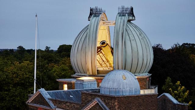
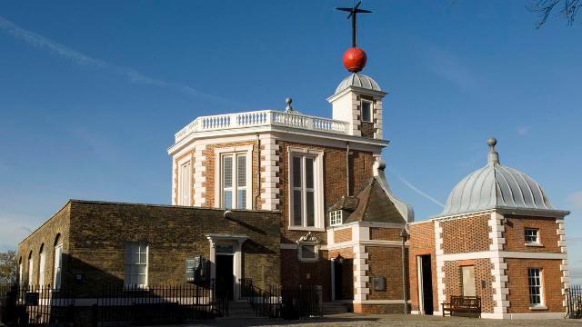
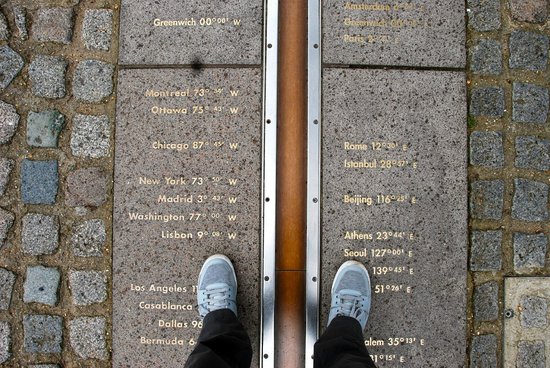
Images of Greenwich Observatory and the Prime Meridian today.
Save the Summer Time!
In the early 20th Century, the luxury London builder William Willett, an avid horseman, noticed during his early ride into the city just how many people kept their blinds and shutters closed to the morning sun. The realisation sparked the inspiration for his seminal essay The Waste of Daylight - the remarkably well-argued piece behind modern British Summer Time (BST). Initially it was argued that in order to maximise the hours of daylight, the clocks should be turned forward 20 minutes on each of the first 4 Sundays in April, and back 20 minutes on the first 4 Sundays in September. Willett’s priority was leisure time (the hours after work) arguing that the extra 80 minutes of light were the “equivalent of a whole holiday every week” and offered countless more hours to improve the health of the body and mind through recreation.
In spite of these promised perks, the proposal was met with huge resistance when it first came into public debate in the early 1900s, despite being enthusiastically backed by Winston Churchill. After various unsuccessful attempts to have the bill passed, BST was finally adopted in 1916, when the national imperitive to save coal and boost productivity was amplified by Britain’s involvement in World War I. Willett sadly never saw Britain’s adoption of his proposal, having died the year before of influenza - you can see a blue plaque above his home in Bromley.
Let's think of him as we welcome back the evening light.
What is the South London Club?

The South London Club is a local discount card to help support small independent businesses across South London whilst saving all who live, work & play in South London money! With over 800+ local discounts to choose from, you will discover & explore all the best hidden gems in South London. Join over 6,000 of us & celebrate all that's independent & South London!